
UCI Views Heavenly Images of Earth
|
Irvine, Calif., Feb. 26, 2007 – The picture just got a lot brighter on Calit2@UCI’s HIPerWall.
A groundbreaking software program developed by Calit2-affiliated postdoctoral researcher Sung-Jin Kim allows satellite imagery, maps, terrain and three-dimensional buildings from Google Earth to be displayed interactively on the HIPerWall.
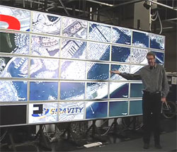
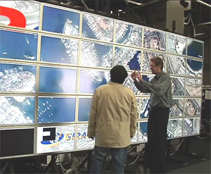
The software’s complex algorithms provide an interface that translates Google Earth images from a laptop to the 50-panel, grid-based display. Now researchers can view the imagery at a 200-million pixel resolution.
|
The 23 x 9-ft. HIPerWall in Calit2’s Center of GRAVITY (Graphics, Visualization and Imaging Technology) at UCI could previously display terrain images only if they were stitched together offline, producing a static image. This approach – which was used with before-and-after pictures from Hurricane Katrina – was tremendously time-consuming and of limited benefit due to its fixed properties.
Stephen Jenks, assistant professor of electrical engineering and computer science, and Kim, his postdoc, had been discussing the possibility of developing a program that could display real-time satellite imagery. It was in conversations with Google that the company suggested utilizing an existing interface in its already widely-used program.
Kim got to work, downloading the Pro version of Google Earth and completing his software interface in two weeks despite some inherent limitations. ”Google Earth is not designed for such a large display wall and for use with multiple machines,” he said. “We are overcoming these limitations by actively collaborating with our counterparts at Google.
“It is very exciting because now we can fully utilize the well-known flexibility of Google Earth,” he added.
All parties are delighted with the outcome. Google is intrigued by the possibility of its imagery becoming available on large, high-resolution displays and Earth scientists are thrilled with the research possibilities. “We’ve wanted to do this for a long time,” said Jenks. “This gives us a level of flexibility in Earth visualization that we’ve never had before.”
The new technology was demonstrated last week in UCI’s Viz lab and beamed via video over an OptIPuter connection to UC San Diego’s Calit2 building, where HIPerWall PI and UCSD Associate Professor Falko Kuester showed it to visiting Google executives.
“It was really exciting,” Jenks said. “This gives us new options in disaster response, GPS tracking and annotated information. We can rotate the view, zoom in and out, and quickly navigate to new locations.
“Now, whatever Google captures at any resolution, we can see it on the HIPerWall.”
View Google Earth on Calit@UCI HIPerWall. [Real player required]