Newsroom > Web Article
Regional Workbench Consortium Featured at ESRI Conference
 |
|
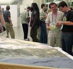
3-D regional canvas of the Californias
|
|
7.9.03 - The Regional Workbench Consortium(RWBC) at UCSD was invited by ESRI to present a special exhibit in the Map Gallery at the annual ESRI conference July 7-11, 2003 at the San Diego Convention Center. This is the world's largest geographic information system conference.
RWBC had a high-profile location at the entrance to the Exhibit Hall's Sail area -- adjacent to exhibits of the National Geographic Society, the Smithsonian Institution, and other prominent organizations. In the words of RWBC director Keith Pezzoli, "it was quite an honor!" The RWBC exhibit displayed UCSD's Urban Studies and Planning Program and the Outreach Core of UCSD's Superfund project (Pezzoli is director of field research for the Urban Studies and Planning Program and co-directs Superfund Outreach Core).
 |
|
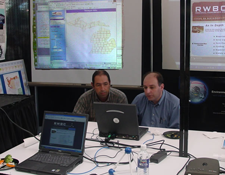
RWBC exhibit
|
|
 |
|
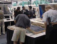
Another view of the RWBC exhibit
|
|
|
RWBC is an academic partner of Calit2. In the words of its Web site, it is "a collaborative network of university and community-based partners dedicated to enabling sustainable city-region development. [It promotes] multidisciplinary research and service learning aimed at understanding how problems of environment and development interrelate across local, regional and global scales. Taking a forward-looking perspective, the RWBC focuses on the Southern California-Northern Baja California transborder region - especially the San Diego-Tijuana city-region and coastal zone."
In addition, Dan Henderson, GIS coordinator at the UCSD Library, won the Grand Showcase award for his poster titled "Monitoring Water, Toxics, and Environment Using GIS 3D Visualization." This was one of six award winners selected from 50 San Diego entries (out of hundreds in the Map Gallery) to the San Diego Geography Showcase, an event held concurrently with the ESRI International Users Conference Map Gallery at the San Diego Convention Center.
For more on the exhibits, see http://www.esri.com/events/uc/exhibits/specialexhibits.html
 |
|
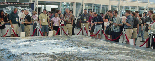
Camp Pendleton (U.S. Marine Corp) Solid Terrain Model (400 square feet at a scale of 1:4000). It's the largest model in the world made with entirely digital data using the same technology Pezzoli's group used to make the 3-D regional canvas of the Californias.
|
|
