

CISA3 Researchers Analyze Native American Site in Push for Digital Archaeology
By Tiffany Fox, (858) 236-0353, tfox@ucsd.edu
Anza Borrego Desert State Park, CA, April 29, 2008 -- Members of Calit2’s Center of Interdisciplinary Science for Art, Architecture and Archaeology (CISA3) at the University of California, San Diego, are developing a three-dimensional digital reconstruction of a local Native American historical site they hope will foster a more widespread use of digital archaeology.
|
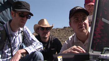
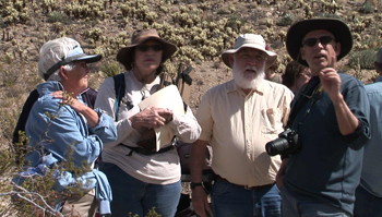
The team, led by CISA3 Associate Director for Archaeology and UCSD anthropology professor Tom Levy, traveled to San Diego’s Anza Borrego Desert State Park last week to analyze the Morteros site. An area of flat bedrock slabs, the site was used up to 1,200 years ago by members of the Kumeyaay tribe to process Mojave agave and yucca plants. The CISA3 team employed a LIDAR (light detection and ranging) laser scanner to create a 3-D model of the site as a means of capturing the full range of groundstone artifacts in the area. The team will then quantify the data to create a “level of detail” algorithm that could be used to perform digital scans of archaeological sites around the world.
Levy and his team anticipate that they will publish their findings in “Internet Archaeology,” an electronic journal published by the Council for British Archaeology.
“This an experiment locally to see if we can apply LIDAR scanning to this archaeological site,” said Levy, who is leading an effort to develop a Digital Archaeology Atlas of the Holy Land (DAAHL) in Jordan, Israel, Palestine, Lebanon, Syria and the Sinai Peninsula. “If we can do it here, we can do it in the Middle East. It’s a lot cheaper to load up our cars in San Diego and try it here. Besides, there is also wonderful hot coffee and apple pie in the village of Julian overlooking the Anza Borrego desert.”
|

If the experiment at the Morteros site proves successful, Levy expects to use the LIDAR scanner in his work in the Middle East sometime in the near future.
To perform their initial scan of the Morteros site, the researchers programmed the scanner to reproduce millions of visual points within a 180-degree area, at a range of 25 meters and a resolution of 2.5 centimeters. The scanner required about 20 minutes to perform the first scan, and the process was repeated from the other direction to allow for the full 360-degree scope of the site. The total range of the scan was 300 meters.
Although the LIDAR scanner was originally purchased for Calit2’s Responding to Crises and Unexpected Events (RESCUE) project, CISA3 recently used it to capture a detailed reconstruction of the Hall of the 500 in Florence’s Palazzo Vecchio (in search of a long-lost Leonardo da Vinci mural). That research and the Anza Borrego project demonstrate that LIDAR can be used for a variety of academic disciplines as well as real-life circumstances. Rescuers might use the instrument to do a quick scan of an area hit by a bomb, for example, or to create an image of a deep cave that cannot be accessed safely by humans.
|
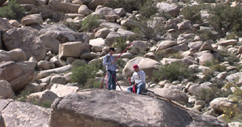
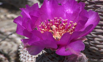
To help “stitch together” the Morteros scans and create cohesive imagery, the team used several tripod-style “targets” as reference points, much as a photographer would use reference points when creating a 360-degree panoramic shot. Setting up the targets required a bit of boulder-scrambling over the rugged terrain, which is home to several varieties of prickly cactus – some of it still in bloom after the spring rains – as well as four species of rattlesnakes.
When the 3-D image is complete, it will provide a visual replica of the Morteros site and its artifacts, including grinding slicks and cupules, or “bedrock mortars,” which were created when the Kumeyaay pounded the agave plants into a pulp for use as food or fiber for making rope, carrying slings, sleeping mats and nets.
With the sound of the scanner’s generator in the background, Sam Webb, volunteer site steward, provided a little history on the Morteros site. The site is named for the Spanish word for “mortar” and was a seasonal “way station” for the Kumeyaay who historically lived in the region. Between the months of March and May, the Kumeyaay would migrate to the region to harvest the agave. Using digging sticks (some of which can be found in the park’s collection of artifacts) male members of the tribe would dig up the agave and peel away the outside leaves, exposing the heart of the plant. The women in the tribe would then use “manos” or hand-stones to process the agave on the bedrock outcrops of quartz monzonite in the area.
|
And how does it measure up, taste-wise?
“It tastes like sweet potato,” he said. “It wouldn’t be at the top of my list, but it’s an acquired taste.”
Processing the agave was hard work and required a familiarity with the ecology of the area. The plants, for example, had to be harvested before their characteristic asparagus-like stalks began to blossom, since the nutritional value of the plant is depleted once it goes into bloom. Park authorities say that certain Native American peoples, including the Paipai in Baja California, still harvest agave in much the same way and use its fibers for handicrafts.
Also advising Levy and his team with their research was Joan Schneider, an associate state archaeologist for the Anza Borrego State Park, who has worked in the area since 2001. She says that the type of detailed digital documentation that Levy and his team are performing could eventually save her and other archaeologists hundreds of hours of time in the field measuring archaeological features and recording their locations.
One such feature is a Kumeyaay pictogram that was painted on a large boulder just steps away from the area the CISA3 team was scanning. Antonino Cosentino, a visiting Italian physicist who has worked with CISA3 on The Battle of Anghiari project in Florence, took several images of the pictogram with a Fuji S3-Pro camera, specially modified with filters for ultraviolet and infrared imaging.
|
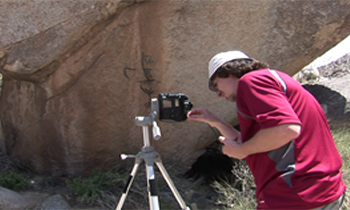
“Different pigments show up differently with an infrared camera,” Cosentino said. “I can distinguish if there are elements that are different with the infrared camera, even it they look similar to the naked eye.”
Although Schneider said that no excavation or radio-carbon dating has been done at the site, she has been taking samples from the bedrock mortars with a solvent of ammonium hydroxide. The samples will be used in a new type of protein residue analysis called Cross-over Immunoelectrophoresis (CIEP). CIEP, originally used in criminology and forensics, is similar to blood-typing in that it tests a sample against a suite of antisera from known plants and animals to check for the presence of certain proteins.
While it’s likely that the Kumeyaay also pounded yucca plants on the bedrock mortars, Schneider suspects that desert animals and waterfowl from local ephemeral lakes were being processed in the same way. Once the protein residue samples are analyzed, Schneider can determine exactly which types of plants -- and possibly animals -- were being consumed by the Kumeyaay.
Levy and his team also hope to gain new insights about the Kumeyaay and their lifestyle once they have completed their digital analysis of the site.
|
“One of the goals of archaeology is to go from the static archaeological record to the dynamics of culture,” Levy said. “What we’re trying to do is use some of the most advanced visualization technologies to reconstruct human behavior. It’s not enough to look at some nice artifacts; we want to look at the people behind the artifacts. We hope to present the local Kumeyaay communities and the Anza Borrego Desert State Park visitor center with a digital model of our work.”
“This does not look like one of the great sites of Rome or the Middle East. It looks like a bunch of rocks,” Levy said of the site. “But it is our local culture and it’s fascinating that we can trace Kumeyaay foraging communities coming in here for over 1,000 years.”
Media Contacts
Media Contact: Tiffany Fox, (858) 236-0353, tfox@ucsd.edu
Related Links