CISA3 Archaeologists Develop 3-D Images of Artifacts for Digital Pottery Informatics Database
By Tiffany Fox, (858) 246-0353, tfox@ucsd.edu
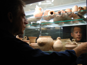
San Diego, Calif. Aug. 20, 2008 — For much of its history, post-excavation archaeological research has relied upon manual drawings of artifacts — drawings that are often time-consuming and expensive to produce, subjective in detail and limited in their two-dimensional scope. More often than not, those drawings depict mere fragments of artifacts, making it difficult for archaeologists to recreate, say, what a delicate perfume juglet must have looked like when it sat intact among the wares of an Iron Age merchant.
|
But with the advent of digital informatics and precise 3-D data visualization — an effort being spearheaded by researchers at UC San Diego's Center of Interdisciplinary Science for Art, Architecture and Archaeology (CISA3) at the California Institute for Telecommunications and Information Technology (Calit2) — the day will soon come when the only detail left to the imagination will be the fragrance that perfume vessel once contained.
A group of UCSD undergraduates, led by UCSD archaeologist and CISA3 Associate Director Thomas Levy and anthropology graduate student Neil G. Smith, are developing a Digital Pottery Informatics Database (DPID) that will integrate new methods for reconstructing 3-D digital images of pottery.
"Most pottery found on archaeological sites is made up of small, broken fragments or 'potsherds,'" Levy says. "The DPID project allows researchers to go from a small sherd to a complete vessel."
In its initial format, the DPID will consist of data from the Iron Age (c. 1,200-500 BCE) ceramic database of the southern Levant, a region of the Middle East that now incorporates areas of Jordan, Israel, Palestine, Southern Lebanon, Syria and the Sinai Peninsula. The 3-D images will eventually be linked to another CISA3 project called the Digital Archaeological Atlas of the Holy Land (DAAHL), a virtual atlas of archaeological sites, artifacts and other information dating from pre-Biblical times to the early 20th century. DAAHL, which is being developed in collaboration with Steven Savage of the Geo-Archaeological Information Applications (GAIA) Lab at Arizona State University and the Chaitan Baru of San Diego Supercomputer Center, will eventually be made available over the Internet to researchers in the field and to the public-at-large.
"Our ultimate goal is to use DAAHL as the first computer atlas node in a larger Mediterranean Archaeology Network (MedArchNet) that will create an on-line community of researchers interested in Mediterranean archaeology," Levy says. "This is what computer scientists call 'portal science' and it has been very successful for geologists, ecologists and other researchers. My students, through the DPID project, are laying the groundwork for analyzing large datasets of artifacts that can be studied spatially in MedArchNet."
Adds Smith: "Rather than relying on all the different books that contain drawings of those vessels, researchers will be able to access all of them at once online and query the data using different variables," explains Smith. "This database will allow archaeologists to conduct a more objective analysis of the typology of ceramics. As for the general public, they will have the opportunity to see what ceramics looked like 3,000 years ago. It's difficult for untrained individuals to understand what they're looking at with only a two-dimensional profile, but once you see it in three dimensions, you have a much clearer idea."
Aside from being visually abstract, two-dimensional profiles are limited in other ways. In a perfect world, for example, a vessel (especially a wheel-thrown one) would be axially symmetric around its center, requiring only a single two-dimensional profile to reveal what the entire object might look like. But in the real world, vessels are often asymmetrical — either due to the original production process or the finishing and decoration processes — therefore a single section as portrayed in a drawing may mask irregularities present in the original vessel. Interestingly, these very deviations in a vessel can reveal the most fascinating information — how well-trained the potter was, for example, what type of equipment he or she was using, what artistic tradition the potter comes from, or whether the vessel was mass-produced or made in a home-based industry. With the type of rich data that 3-D imaging provides, researchers might even be able to identify individual potters in the archaeological record.
|
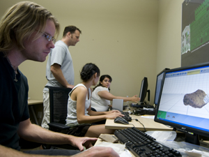
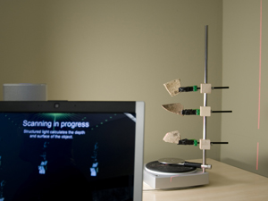
To create the necessary 3-D algorithms for this type of extrapolation, CISA3 researchers and anthropology major Eric Olson is using a Next Engine© laser scanner to obtain triangulated meshes of the potsherds which can later be converted into any 3-D vector format (2-D images generate raster, or dot-based images, but vector, or shape-based images, are more amenable to mathematical manipulation). Since all the 3-D scans done by Olson can also be imported into MATLAB (a numerical computing environment and programming language), they can compare and analyze, in the same format, both the 3-D scans and 2-D vectors of images taken from archaeological publications.
Using a Fourier curvature function developed in MATLAB by Avshalom Karasik and Uzy Smilansky of Israel's Weizmann Institute of Science, anthropology major Sorayda Santos, and anthropology/biology major Charlene Wang take 2-D raster images vectorized in Photoshop to create a mathematical algorithm representing the exact curvature of the vessel's form.
International collaborations between CISA3 and institutions like the Weizmann Institute are critical for "pushing the envelope" of archaeological research, Levy says.
In addition, Santos and Wang are working to demarcate corresponding archaeological sites in Google Earth, a Web-based virtual globe comprised of images from satellites, aerial photography and global positioning systems (GPS).
"We were given a list of about 30 key Iron Age sites, but a lot of them are old sites that were excavated before GPS," Santos says. "We basically had to figure out where those sites were, even though we didn't really have any coordinates or other details. Some of the descriptions would say 'Mountain, Southern Jordan,' so that really didn't help. We literally had to look at different mountaintops in Google Earth to try to figure out which ones where which. And when you zoom in with Google Earth, at a certain point it gets blurry, so sometimes we couldn't tell if we had the right place or not. We checked these locations with our professor."
Through trial and error and a lot of hard work, Santos and Wang were able to identify each of the sites, which will prove indispensable to researchers in the field.
"We'll also be putting the vessel algorithms online so researchers can query based on similar vessel forms or by archaeological site," Smith says. "For example, if you have one vessel and you know the algorithm for it, you can search for vessels that have a similar algorithm to see what other archaeological sites might have contained those same vessels, or you can find out how many of that type of vessel are in the site you're studying. In this way, we can compare the typology for different areas, map trade locations and contrast areas that have similar cultures."
Right now, Levy's team is scanning about 20 vessels per day (twice the number of images a good manual artist can create), and they've recently discovered a way to scan four vessels at once, which should significantly increase their output. But things weren't always so productive. The team was originally using a structured FlexScan 3-D© light scanner with Leios Mesh software in UCSD's Center for Research in Computing and the Arts (CRCA) at Calit2, which became an arduous task.
|
"We were having countless problems because of the material we were trying to scan," Olson says. "First of all we had to calibrate the system, and after taking eight photos of the calibration grid for each sherd, we had to align the grid with the projector. Once the alignment was set, we couldn't move anything on the table or it would get knocked out of alignment, but since other researchers were also using the CRCA lab at the same time, things were getting knocked over."
"FlexScan is a great program," Smith adds, "It's just that for our specific use, it was taking too long to do. Primarily, the stitching of multiple scans together wasn't giving us fast enough results."
With only about 12 weeks at their disposal (several of the researchers are on fixed summer internships), the team had intended to complete 100 scans. But after several days at work in the lab with FlexScan 3-D, they were finding it difficult to get even one or two complete 360-degree scans. With Levy at work in South America in an area with limited email access, they knew they had to take initiative and find a solution fast. So they did what any college students would do: They took a road trip.
"We found out about this scanner called Next Engine, which was a reasonable price and had the software, the scanner and the rotating table all in one," Smith explains. "It seemed like it was the best solution, but from our experience working with FlexScan 3-D , we knew there are always problems doing the scanning. So we decided to go up to Santa Monica to visit the company and have them demo it. We actually brought some of our sherds to see if they'll be compatible with the scanner. We found out the scanner did exactly what we wanted it to do."
Next Engine, which can scan a potsherd as large as 13.5 by 10.1 inches, has primarily been used by those in the retail industry to create 3-D images of merchandise for marketing purposes (Nike has used it in the past to scan shoes) or for reverse-engineering. Smith says he heard about one individual who used Next Engine to scan his collection of live iguanas.
"The price range makes it affordable for everybody," he adds. "We were looking for inexpensive scanners that other archaeology researchers with small research budgets could afford, since usually scanners cost in the range of $10-50 thousand. That's just completely out of the budget of anyone who wants to do archaeological research. Next Engine only cost $2,500." (When Levy returned to CISA3, he was happy to cover Smith's research expense).
With this new technology at their fingertips, the team expects to exceed their goal of 100 scans and complete 200 fully scanned vessels by the end of the summer. These vessels will then be converted into two-dimensional digitally drawn profiles for publication. They will also be converted into the curvature functions for comparison to the 2D drawings vectorized by Santos and Wang.
In the future, Levy expects 3-D informatics to become a well-utilized tool among archaeologists worldwide.
"The DPID project ultimately contributes to CISA3's goal of utilizing advanced information technology (IT) tools to promote international collaborative research and publication," he says.
"Digital scanning of artifacts will probably never replace the need for a scientific illustrator on a dig for those wonderful special finds — like a bronze dagger or crystal skull — that will go into museums. However, given the massive quantity of artifacts we retrieve on digs each year, archaeologists will need to get out of their comfort zones using traditional methods if they are to confront the realities of analyzing huge datasets and then publishing them in a timely manner."
Media Contacts
Tiffany Fox, (858) 246-0353, tfox@ucsd.edu
Related Links
CISA3


