

Coastal Bluff Study Seeks to Understand Processes That Cause Cliff Failures
By Tiffany Fox, (858) 246-0353, tfox@ucsd.edu
San Diego, CA, Nov. 7, 2008 — The cliffs along the San Diego coastline are more than just fodder for picture postcards; a number of residential homes sit perched atop them, and in certain areas, the railroad tracks that serve Amtrak and County Coaster come within several feet of the cliff edge.
|
But coastal erosion is changing the landscape of Southern California's beaches, and a team of researchers from UC San Diego is seeking to better understand how waves, groundwater sapping, and sea-level rise are contributing to the gradual eating-away of the beachfront cliffs that line the 20 kilometers between La Jolla and Encinitas.
"The purpose of our study is to acquire quantitative images of the cliffs from every angle, down to centimeter accuracy,” says principal investigator Neal Driscoll of the Scripps Institution of Oceanography’s Geoscience Research Division. “We do this by conducting repeat surveys so we can determine the size, location and timing of cliff failures. Based on this information, we try to understand the processes that caused the failure.”
Assisting Driscoll with the study are Michael Olsen, a graduate student researcher from the UC San Diego Jacobs School of Engineering's Department of Structural Engineering, and Scripps’ Liz Johnstone, a Ph.D. candidate in oceanography with a specialty in marine geology. Olsen is a member of the Graphics, Visualization and Virtual Reality Lab (GRAVITY) in the UCSD division of the California Institute for Telecommunications and Information Technology (Calit2). GRAVITY is directed by Structural Engineering Professor Falko Kuester, Olsen's advisor and a co-PI on the coastal-bluffs project.
Notes Olsen: "There's a lot of investment in both public and private infrastructure on the cliffs and beach, and ultimately, those involved are going to need good data as to what to do in terms of this erosion, and how to best use our tax dollars."
Driscoll, along with former Jacobs School of Engineering Professor Scott Ashford and graduate student Adam Young, received funding from California Sea Grant to quantitatively map cliff erosion in the southern Oceanside Littoral cell to test their new hypothesis that bluff erosion contributes more sand to the beach than previously thought. In 2005, the duo discovered that sea cliff erosion contributed 68 percent of the sand covering the county's beaches, and a concurrent study by Driscoll and graduate student Jennifer Haas used a "mineralogical fingerprinting" technique to conclude that 50 percent of the sand came from erosion of the bluffs.
The studies caused some concern among members of the local scientific community, since it was formerly thought that only 10 percent of beach sand came from cliff erosion, with 90 percent of sand coming from local rivers that empty into the sea.
|
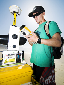
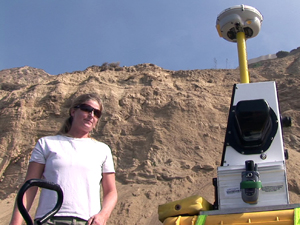
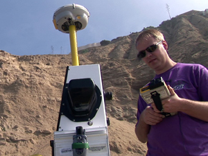
Olsen and Johnstone have spent two years using an I-site 3D laser scanner to conduct a three-dimensional, geo-referenced time-lapse study of the cliffs from Black's Beach in La Jolla to Beacons in Encinitas to determine how quickly the cliffs are eroding, and why.
The study will not only provide data in terms of danger to property, but may provide insight into how best to protect local citizens from the massive cliff failures that periodically occur. In August, a tourist from Nevada was killed when a small section of cliff just north of Black’s Beach released basketball-sized blocks and hit him on the back of the head. A section of Torrey Pines State Beach was closed last month after nearly 1,000 tons of earth fell onto the sand.
"Certain vulnerable areas or zones of instability could go anytime," Johnstone warns. "These areas are prone to erosion during both rainy and extremely dry seasons, depending on the sediment characteristics of the cliffs. The hot spots can be dangerous not only for those living and developing on top of the cliffs, but also those on the beach. We try to educate the public as we survey, but inevitably we often witness people sitting directly under signs that say 'Stay back — unstable cliffs.'"
The team is in the process of making an educational brochure featuring tips on how to stay safe when near the cliffs, and has also incorporated a rapid-response effort into its work: "We hear about a failure and go out immediately to scan it," Olsen says.
But scanning the cliffs isn't as simple as taking a photograph. With lots of heavy gear and a long, winding coastline to cover, it's often a labor-intensive process. On the days they're out in the field, Olsen and Johnstone, along with fellow graduate students Jessica Raymond, Pat Rentz, John Sorenson and Jillian Maloney, haul a custom-fitted yellow wagon filled with high-tech instruments along the beach during low-tide cycles, sometimes covering several kilometers in a day.
The scanner, along with a global positioning system (GPS), determines geographical coordinates and generates a 3D data 'point cloud' of the surrounding cliffs, which can be measured from up to 500 meters away. Instead of control markers (which cannot be set up on the beach because the landscape is always changing), the team uses the GPS to connect to the California Virtual Reference Station (Calvrs), a set of GPS base stations that allows the researchers to correct for certain disturbances in the ionosphere, or the uppermost part of the atmosphere.
The team conducts scans during the spring and autumn months to determine how winter storms and summer droughts have affected the landscape. But just because it's springtime in San Diego doesn't mean it's warm — Johnstone remembers a wet, chilly morning on the beach when a lifeguard took pity on the research crew and bought them all hot chocolate. Scanning during the summer is usually out of the question since there are too many people on the beach, Olsen observes, but the team must still occasionally extract extraneous data points from their scans, such as beach umbrellas.
|
The researchers would like to continue their time-series analysis to document the effects of El Niño cycles, which happen on a two- to seven-year cycle, as well as Pacific Decadal Oscillation or PDO cycles, a pattern of Pacific climate variability that shifts every 20 to 30 years. Also under examination are the effects of sea-level rise (2 millimeters per year) due to thermal expansion of the ocean.
"We also take samples of sediment from the beaches and cliffs surrounding hot spots and analyze the minerals to determine what fraction of the failure may remain on the beach and to assess if there is a lithologic [rock outcrop] control on cliff failure, " notes Johnstone. "In addition, we correlate the timing of the failures with wave energy data and precipitation data in order to determine potential triggers for cliff failures in the region."
"There have been no legal or policy changes as a result of this research because this is new research, and it's a time-series," she adds. "We're just starting to look at the seasonal change data, so we can't state long-term cliff erosion rates yet, but we're hoping we can keep this study going for a while, because what we need is a good 10 to 20 years in the field. You have to be consistently monitoring the cliffs to be able to quantify changes."
Kuester, who is Olsen's adviser in Structural Engineering, says the project has an immediate societal impact and is a "great example of research at the interface between fundamental science, engineering, and information technology."
"Michael and Liz are doing pioneering work in coastal bluff erosion monitoring, modeling and analysis, including advanced visualization and virtual reality techniques, while at the same time engaging the community and raising awareness about the processes at work," he enthused. "They are great role models for the next generation of scientist and engineers that have to be able to tear down traditional domain boundaries while driving innovation."
Media Contacts
Tiffany Fox, (858) 246-0353, tfox@ucsd.edu
Related Links
Project Web Site
Scripps Institution of Oceanography