New Cyber-Archaeology Research Lab Brings State-of-the-Art Technologies to Jordan
By Tiffany Fox, (858) 246-0353, tfox@ucsd.edu
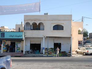
San Diego, Calif., March 30, 2011 — Some of the world’s most advanced archaeological research is taking place not at a dusty excavation site, but in a tiny laboratory atop a vegetable market in southern Jordan, where archaeologists from UC San Diego have traded in their picks and shovels for databases and digital tools.
|
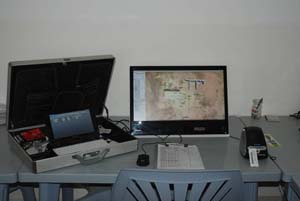
Known as the UCSD CISA3 Jordan Cyber-archaeology Lab, the facility was established in the village of Shobak, Jordan as a year-round state-of-the-art research and training facility for UCSD graduate students and other foreign scholars, as well as Jordanian archaeologists interested in digital archaeology tools. The lab is a showcase for advanced digital methodologies to find and protect artifacts of cultural heritage — methodologies established at the Center of Interdisciplinary Science for Art, Architecture and Archaeology (CISA3), based in the UC San Diego division of the California Institute for Telecommunications and Information Technology (Calit2).
“UCSD has five different archaeological field projects in Jordan conducted by UCSD CISA3 faculty, staff and graduate students,” notes UCSD anthropology professor Thomas E Levy, who is also associate director of CISA3. “It is impossible to ship all the artifacts recovered from these excavations out of the country, so it is important to have a local presence where we can apply the same digital archaeology techniques we carry out at UCSD, but in Jordan around the year.”
Academic scholarship in nearly every field — including archaeology — is facing a monumental shift as researchers enter into what computer scientists refer to as the “Fourth Paradigm” of scientific discovery based on data-intensive computing.
“To handle this worldwide ‘data avalanche’ — from digital photos to LiDAR scans with billions of data points — we need to develop massive data storage systems, scientific workflows and advanced visualization displays,” explains Levy. “The UCSD CISA3 Cyber-archaeology Lab in Jordan, in tandem with CISA3 here on campus, is helping to lead the way in developing e-Science for archaeology."
Levy says that the Cyber-archaeology Lab in Shobak will serve as a base for students who plan to spend extended periods of time in Jordan, which is one of the key test-beds for interdisciplinary research projects CISA3 is developing as part of a five-year, $3.2 million grant from the National Science Foundation's Integrative Graduate Education and Research Traineeship (IGERT) program.
|
Calit2's divisional director at UCSD, Ramesh Rao, says the lab is an example of the institute’s mission to transform a multitude of academic disciplines through information technology.
“Right now, what goes on at most excavation sites is that archaeologists will do a dig, extract artifacts and leave a pile of dirt,” says Rao. “With this approach, all sorts of valuable information is uncovered and then lost.
“The digital tools available to researchers at the Cyber-archaeology Lab will allow archaeologists to geo-encode structures in the field and then visualize them after the dig, so they don’t lose detail pertaining to location, spacing or depth,” Rao continues. “Even more importantly, once the data is digitized, archived and made available on the Internet, people who would never ordinarily visit a dig site can virtually re-excavate the same site many times over. This kind of technology doesn’t just create a substitute for the real experience, it enhances it.”
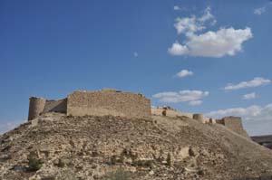
Calit2 Research Associate Neil Smith will head up the new lab in Jordan, which officially opened in August of last year. Smith, who is one of Levy’s former graduate students, received his Ph.D. in anthropology from UCSD in 2009 and has since made Jordan his home. Neil lives in the Shobak village with his wife Kristiana and their two sons. Shobak is home to a famous Crusader fortress that was attacked a number of times by Salahuddin Al-Ayyoubi (Saladin) before he captured it 1189 – fewer than 75 years after it was constructed. Today the area produces figs, olives, grapes and other crops.
Says Levy: “Neil's talents in Levantine archaeology, IT and computer programming make him uniquely qualified to 'push the envelope' in applying digital technologies to both excavation methodologies and artifact data processing.”
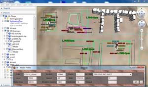
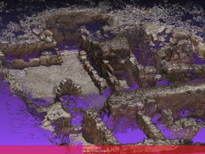
One state-of-the-art technology Smith and Levy have developed for use in the lab is a real-time web-based 3D visual recording tool known as ArchField. The geographic information system (GIS) software, which is open-source and compatible with any operating system, allows archaeologists to capture data about artifacts and excavation sites using GPS devices and total stations (the electronic/optical instruments used in modern surveying) and then convert the data into a 3D projection so it can be visualize
|
“The big advancement of ArchField is that to date there’s never really been a program to help archaologists record data using total stations,” explains Smith. “There is a lot of proprietary software already in existence, but it’s more designed for surveyors and survey-type work in the industrial sector. We wanted to design a program that met our needs as archaeologists.
“One of the big reasons we wanted the program to be open source and free is because we want to revolutionize the way archaeologists do recording in the field,” adds Smith. “Most archaeologists don’t have the funding to spend thousands of dollars on equipment. This software can be used for all projects, both big and small.”
The UCSD team conducted an alpha testing of ArchField this summer at an Iron Age (ca. 1200-500 BCE) excavation site in Shobak called Khirbat al-Iraq (khirbat means “ruins” in Arabic). Using Leica total stations, they gathered more than 3000 points of data pertaining to site architecture and in-situ ceramic vessels.
Explains Smith: “In the past you would have to measure out the perimeter of the site with measuring tape, try to draw the site by hand and take the elevation measurements with a dumpy level. Sometimes this information would be scanned and digitized later. But with our new technology, all of this is now completed before we leave the field at the end of the day. The information is color-coded and stored in a database right there in the field, and it’s 100 percent accurate to within a centimeter. You can record a radiocarbon seed with total station and then immediately see the location of the seed in Google Earth in its exact location.”
|
“The labels were done by hand in the past,” notes Smith. “In past seasons we bought hundreds of Sharpies for writing labels, but with ArchField as our primary recording tool, we only had to buy 10 Sharpies this season.”
The software is currently compatible with Leica Total Stations, but the team eventually plans to make the interface compatible with other brands of total stations. Plans are also in place to adapt the software to record data using ground-penetrating radar and other non-invasive field techniques.
ArchField is only one of many high-tech tools available to archaeologists working at the Cyber-archaeology Lab in Jordan. The Digital Pottery Informatics Database, which was also developed by researchers at CISA3, integrates the latest digital methods for reconstructing 3D digital images of pottery. Those images will eventually be linked to another CISA3 project called the Digital Archaeological Atlas of the Holy Land (DAAHL), a virtual pan-regional atlas of archaeological sites, artifacts and other information dating from pre-Biblical times to the early 20th century. DAAHL, which is being developed in collaboration with Stephenen Savage of the Geo-Archaeological Information Applications (GAIA) Lab at Arizona State University and Chaitan Baru of t
|
Adds Levy: “With LifeSize Passport and other high-definition virtual telepresence technologies, our Cyber-archaeology Lab in the small Jordanian village is integrally linked to Calit2 here in San Diego, helping to ensure real-time collaboration and research.”
UCSD’s counterparts in Jordan are also working to harness the power of technology to preserve the country’s cultural heritage. The Department of Antiquities of Jordan has developed, in partnership with the Getty Conservation Institute, a bilingual Arabic-English, Web-based national GIS for Jordan's antiquities, known as the Middle Eastern Geodatabase for Antiquities (MEGA).
“When people talk about tourism in Jordan, they’re talking about archaeological sites in the Holy Land,” notes Professor Ziad Al-Saad, director of Jordan’s Department of Antiquities. “We must keep safe Jordan’s heritage treasures for future generations.”
Adds Levy: “The range of cyber-archaeology projects CISA3 is doing in Jordan complements these national efforts to deal with the data deluge in Middle East archaeology.”
Media Contacts
Tiffany Fox, (858) 246-0353, tfox@ucsd.edu
Related Links
Center of Interdisciplinary Science for Art, Architecture and Archaeology (CISA3)
Integrative Graduate Education and Research Traineeship (IGERT)


