

Smarr Receives Lifetime Achievement Award at ESRI Conference
By Stephanie Sides
|
San Diego, CA, August 10, 2006 – Larry Smarr received the ESRI Lifetime Achievement award from Jack Dangermond, co-founder and president of ESRI, the world's leading Geographic Information Systems (GIS) software company headquartered in Redlands, CA. This ceremony was held as part of the keynote plenary session of the 26th Annual ESRI International User Conference, attended by 14,000 ESRI users, scientists, engineers, and students from 200 countries around the world. This event focuses on how GIS technology can better serve the world and our communities, and is the largest GIS event in the world.
In presenting the award, Dangermond described Smarr as the “leader of the supercomputer movement.” In a relationship between the two that goes back more than15 years to when Smarr was director of the National Center for Supercomputing Applications, Dangermond said he thought Smarr was joking many years ago when the latter suggested implementing ESRI’s ARC/INFO software on NCSA’s Cray supercomputer.
Smarr’s vision of how the Internet, the web, and visualization could transform the workstation-based GIS of the early 1990s had major influence on multiple generations of ESRI’s software architecture design, said Dangermond.
“Larry can see the future,” he said, “and he has a mind that understands intricacies and detail against the backdrop of the larger scientific and engineering picture. He understands deeply both content and context simultaneously. For these attributes, his accomplishments, and his understanding and promotion of the value of GIS, we present him with this award.”
|
||||
Smarr spoke for 15 minutes, focusing on the power of geographic imagery and optical networking to bring ever-higher-resolution imagery to bear on scientific problems. “We’re preparing for a world in which distance will effectively be eliminated,” he said.
One-hundred-foot-resolution images are being replaced by one-foot-resolution images -- 10,000 times the resolution of Landsat images. “That makes for 1-billion-pixel images,” he said. “Post 9/11, the U.S. Geological Survey is creating such imagery of the100 largest cities in the US." Smarr showed such high-resolution images of New Orleans after Hurricane Katrina – work in collaboration with Calit2 affiliate Eric Frost at San Diego State University – on a 100-megapixel tiled display at Calit2, developed by Calit2’s partner, the Electronic Visualization Laboratory at the University of Illinois at Chicago. “This type of display will be tomorrow’s Web browser,” he said.
Optical networking, particularly the spread of the National LambdaRail, provides the power behind such display devices. “We’re entering an era,” said Smarr, “similar to when, in the computing world, we moved from mainframes to desktop PCs. Now we’re moving from the shared Internet to having our own dedicated gigabit wavelengths of light, or 'lambdas.'”
A related shift is taking place, too: Whereas the computer used to be the center of what’s come to be known as cyberinfrastructure, that role is now being ceded to 10-Gbps optical fabric with everything else – compute CPUs, storage, visualization displays – becoming peripheral.
|
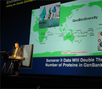
“Such ‘pipes,’” said Smarr, “are beginning to link the backplane in your Linux cluster, for example, to huge databases as if they were local peripherals in your research lab.” He alluded to the CAMERA project at Calit2, a marine microbial metagenomics server complex being created in partnership with the J. Craig Venter Institute and the Scripps Institution of Oceanography, as one of the databases that will be accessed this way.
Add to that the power of high-definition, photo-realistic video feeds from anywhere in the world, and you have a good idea of how children will learn about science in the next 10-15 years. In this context, Smarr shared with the audience stunning high-definition (HD) video of the abundant life of the hydrothermal vent on the ocean’s floor. He briefly described Calit2’s LOOKING project led by John Delaney at the University of Washington in which this live HD video stream was fed from the seafloor 2.5 kilometers below the ocean surface, through the University of Washington’s Research Channel, to a very impressed audience in San Diego at iGrid 2005, "the Woodstock of Networking" event last September.
“Projects like CAMERA and LOOKING,” he said, “are technology enablers for greatly increasing our understanding of the ‘geo-biodiversity' of our living planet. This will become a primary driver of high-resolution GIS in the future.”
In a decidedly political conclusion that was received with applause by the audience, Smarr said, “We’re going to have to make some tough decisions about our planet in the coming years. Wouldn’t it be better if those decisions were driven by solid GIS data and scientific reasoning, rather than who’s the richest, who has the most political power, or who has the most weaponry?”
Smarr shared the stage with former democratic senator from Nebraska Bob Kerrey who came to appreciate the power of GIS during his 12 years in Washington where he commonly was overwhelmed by the deluge of information he had to digest. Kerrey is now president of The New School in New York City. He’s used his interest in GIS to create the Parsons Institute for Information Mapping. With his admittedly political background, Kerrey and his students are working on a major research project, titled "The PIIM Voting Tool," that will track the power of issues in American presidential electoral contests and demonstrate the importance of the Electoral College in determining the president. By revealing the complex relationship between majority voting and the winner-takes-all, state-by-state process, PIIM makes it possible to manipulate primary and election results based on different hypothetical outcomes and enables better understanding of critical aspects of campaign politics. Kerrey exhorted the audience, “May your work bring out the best in all of us.”
After ribbing Kerrey about his resistance to returning to politics, Dangermond concluded the session with some speculation: “You can just imagine the power of GIS-literate leadership…"