

From Image to Impact
By Fran Tardiff
Oct. 18, 2006 --On the day after Hurricane Katrina’s 125 mph winds bombarded New Orleans and much of the Gulf Coast , Charles Huyck flew in a three-person Cessna over the devastated area recording images on high-definition video.
Even as people on the ground had yet to grasp the extent of the damage, he witnessed the flooding, breached levees, shattered houses, and people waving from rooftops and highways, and trickling into the Superdome. Huyck stayed four days shooting timely, bird’s-eye pictures to complement later satellite images.
|
He was there in his role as senior vice president of ImageCat, Inc. a company partnering with Calit2 researchers on the ResCUE project to improve urban crisis response. Taking quick, accurate visuals of a crisis as it unfolds is one part of that multidisciplinary mission.
“Emergency response is all about getting the right information to the right people at the right time,” says Huyck. Exploring GIS (Geographic Information Systems) and other technologies to reach that goal has been the focus of Calit2 and ImageCat investigators since 2003 when they began collaborating on the $12.5 million NSF-funded ResCUE project.
Estimating Damage with Custom Scenarios
ImageCat President/CEO Ronald Eguchi and Huyck founded the Long Beach, Calif.-based company of scientists, engineers, urban planners, geographers, computer scientists and other experts in transportation, remote sensing and visualization technologies. They are innovators in the field of emerging technologies that assess and manage the complex issues associated with natural or man-made disasters. The name ImageCat derives from the term “image catalogue,” as in the existing database of satellite images used to estimate damage, to a city or region, and come up with loss estimates.
|
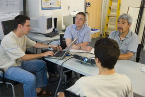
The company’s relationship with Calit2 began five years ago when Sharad Mehrotra, UCI professor of computer science, and other faculty met informally with ImageCat executives to discuss applying technology to disaster response. “UCI has a lot of expertise in IT solutions and ImageCat is expert in the domain of disaster response,” says Eguchi. “It was – and continues to be – a good match.”
Simulating Emergency Responses
Specifically for ResCUE, ImageCat research focuses on loss estimation and transportation routing in order to model disaster impacts – with and without technology integration. Comparing the results can identify which technologies are most likely to be effective, and may be used in learning how to implement the technologies.
ImageCat works closely with students and staff at UCI and UCSD in the development of MetaSim, a series of simulated environments, or testbeds, where researchers see how various technologies might work in a disaster, namely an earthquake. In an evacuation scenario, the simulations help to answer questions such as: Would it be better to tell people to take specific roads, or would randomly fleeing the scene be more effective? Are there ways to alert people to potential dangers for more effective evacuation of buildings? Different technologies are simulated, including cell phones, freeway message boards, Internet-based dissemination or a combination.
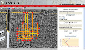
At the core of the company’s role in the development of MetaSim is INLET: Internet Based Loss Estimation Tool, the first online tool of its kind. INLET calculates probable damage using custom earthquake scenarios where a user assigns a magnitude and epicenter to any location on a map. If an actual earthquake occurs, INLET can read U.S. Geological Survey-produced ShakeMaps of ground motion intensities and estimate damage within minutes of an earthquake. This information helps to calculate damage over an entire region and the impact on a transportation system, thereby helping first responders and other agencies to better prioritize their activities. The information could also be used in planning before a disaster. “INLET is unique because it’s online and integrated with near real-time earthquake monitoring, providing more accessible, thus more usable, information than traditional loss-estimation tools,” says Eguchi.
Saving Lives with Information
“People die from not knowing what’s going on in an emergency, where to obtain aid, where to go to be safe,” says Huyck whose passionate dedication to this area of research comes from gathering data at many disaster sites – from a 1999 earthquake in Turkey to Hurricanes Katrina, Dennis, Rita and Wilma.
He and ResCUE colleagues envision that crisis and transportation modeling systems developed during the project could live on as artifacts, or products, of the work now being done. If their vision is realized, “The legacy of ResCUE will be that research prototypes and tools like INLET will be put into practice by emergency first responders to save lives and property, and minimize economic impact in a crisis,” Eguchi adds.
When Huyck first got into the business about 13 years ago, he thought that GIS could be used to save lives. “People said ‘no way.’ Now we’re talking about real-time data and Internet mapping, which everyone recognizes can be used to prioritize crisis response.
“We still have a long way to go,” he adds. “But you only have to go to one catastrophic event where entire regions are decimated and people are injured, homeless or dying to know that this work is important.”
Related Projects
Responding to Crises and Unexpected Events
ResponSphere