

Calit2 Provides High-Tech Help During Wildfires
November 1, 2007 / By Maureen C. Curran
|

San Diego, CA, November 1, 2007 -- California Institute for Telecommunications and Information Technology (Calit2) researchers reacted to the recent wildfires in the same way as many other San Diegans, they went with their strengths -- using ongoing research, tools and techniques, as well as calling on affiliates -- to help the community, both while the flames raged and now as many are having to rebuild their lives and the community begins to recover (albeit tentatively, because new Santa Ana winds are expected this weekend).
One of the greatest needs in the recent fire storms was accurate and timely information, and frequent updates to keep up with the unusually fast-moving fires. Information about the fire storms was sought by literally millions of people locally, nationally and internationally. This presented a big problem for a Calit2 affiliate.
The San Diego State University (SDSU) Web Fire Mapping Services was one of the best sources of up-to-date maps, images, and official information. However, site responsiveness ranged from extremely slow to inoperative due to the extremely high number of hits it was receiving. "Larry Smarr suggested and authorized changing the server to the Calit2 web server complex, which made the website a robust and highly available asset during the fires," said Eric Frost, a long-time Calit2 affiliate and co-director of SDSU's Center for Information Technology and Infrastructure (CITI, home of the SDSU Visualization Center). Smarr is the director of Calit2.
|
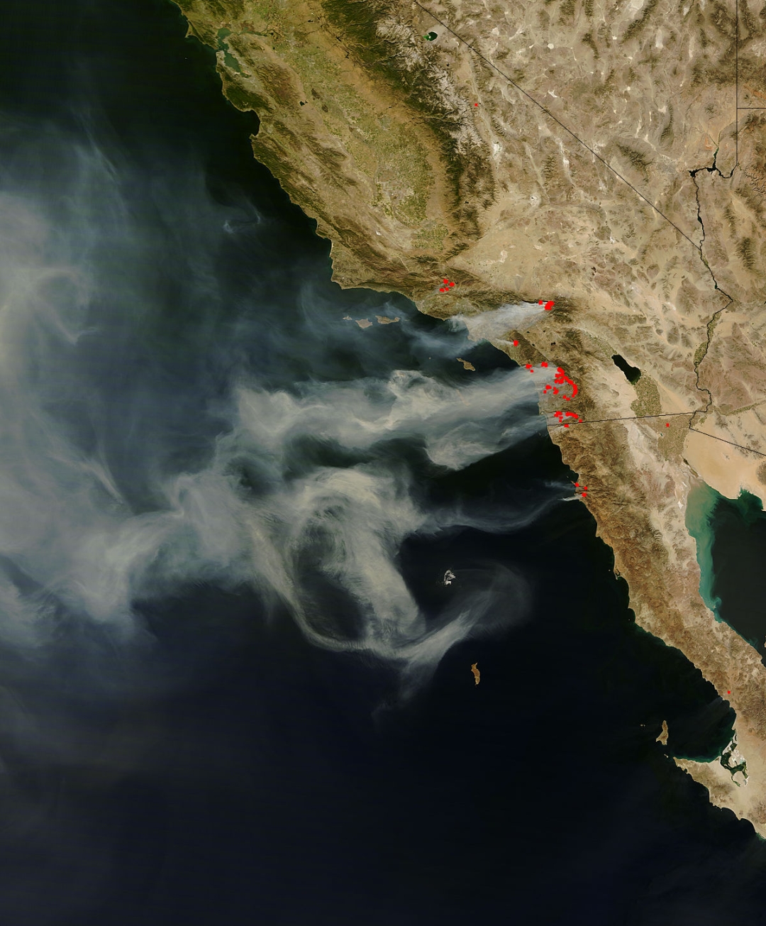
Timeliness is always important in emergencies and disasters, never more so than with these Santa Ana wind-driven fires, which were exceptionally quick moving. On Monday October 22 around noon, as the fires raced westward, Smarr emailed the Goddard MODIS and EO-1 satellite image teams within NASA to ask if it would be possible to speed up their processing of fire images so they could be used in time for fire control. And he brought them together to work directly with SDSU's Frost and John Graham, who then produced a whole series of secondary images. Smarr previously served as Chair, NASA Earth System Science & Applications Advisory Committee and as a member of the NASA Advisory Council to the NASA Administrator.
For more information on the joint efforts of Calit2, SDSU's Visualization Center and NASA to create and disseminate tactical wildfire imagery, please see related article, [click on title: Calit2, San Diego State Univ. and NASA Create Imagery to Support Wildfire Response].
As the magnitude of the Southern California fires became apparent, Calit2 also began to apply a number of tools that had been developed as part of our ongoing Research Intelligence efforts to quickly aggregate breaking news on the fires in San Diego. These tools, built on smart real-simple syndication (RSS), allowed Calit2 staff member Jerry Sheehan to provide half-hour updates for the first three days of the fire. (Due to the UCSD campus closure these updates were provided on his private blog, link below.)
The blog relies on "social" tagging to enable the breaking news to be more easily found by interested parties. During the first week of the fire this information had 14,720 page views and was featured on sites including BoingBoing (one of the top blogs).
Now that the immediate crisis has passed, efforts will focus on creating a Calit2 California Digital Archive based on the real-time posts, maps, photos, and links generated from the first week of the massive and multiple brushfires. The goal of these efforts is to create a rich archive of materials that can be used to evaluate crisis response and patterns of emergency communication. Such "peer-to-peer" communication was widely used by the pubic during this time.
|
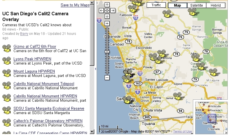
Another effort by Calit2 researchers to aggregate and publish existing resources, thereby easing access to the information, was led by Ramesh Rao, the director of the UCSD division of Calit2. Early on, a Google Maps overlay produced by KPBS was identified as one of the most reliable information sources regarding the location and status of the fires, as well as the location of the numerous county, city, and private resources and evacuation zones.
Calit2 researchers contributed to the available Google Maps-based information by creating an overlay showing the location of 18 cameras already deployed throughout San Diego county and making their high quality video feeds available to the public by clicking a feed icon on the map. As a result, from one website, one map, any interested party can obtain a first person view of the conditions from numerous central and remote locations throughout the county in real time. New cameras will be added to the overlay as they become known.
Fifteen of the cameras belong to the HPWREN (High Performance Wireless Research and Education Network), an National Science Foundation funded network research program, which also functions as a collaborative cyberinfrastructure on research, education, and first responder activities. Users can view the cameras in real time, or they can access movies and images collected by HPWREN (currently back to June).
"An interesting example is the Lyons Peak (East) camera on the afternoon of October 24 (3 p.m. to 6 p.m.) which dramatically shows the fire advancing up the peak," noted Barry Demchak, a RESCUE project software architect. [Click here to see animation; a Quicktime plug-in is required for the browser.] For more information on the HPWREN camera use during the fires [click here].
Calit2 UC Irvine staffers and affiliates have also contributed significantly to the tools available to Southern California. Links to their respective articles can be found below.
Related Links
Calit2 Google Maps Overlay
Calit2 Research Intelligence Portal
SDSU Web Fire Mapping Services
Jerry Sheehan's blog/aggregated wildfire coverage
BoingBoing coverage of Sheehan's blog
HPWREN
Related Articles
Calit2, San Diego State Univ. and NASA Create Imagery to Support Wildfire Response
RESCUE Engineer Helps City Respond to Wildfires
Web Site Launched to Help California Wildfire Victims
Media Contacts Maureen C. Curran, 858.822.4084, mcurran@soe.ucsd.edu