

HPWREN at 10: UC San Diego's Wireless Research and Education Network Benefits Scientists and Societies in Southern California
San Diego, Feb. 22, 2010 -- The vision transformed into a concept from atop a hill. More precisely a mountain, as Hans-Werner Braun, a research scientist with the San Diego Supercomputer Center at the University of California, San Diego, looked off into the distance from Mount Woodson 10 years ago this month and imagined a network of wireless Internet connections crisscrossing this boulder-strewn landscape that's well known as a mountain climber's paradise, despite being less than 20 miles northeast of San Diego's smooth and sandy beaches.
|
The vision was created through conversations with Frank Vernon, a UC San Diego seismologist and part of the survey team, who had originally contacted Braun in April 1999 and expressed interest in creating a faster, more reliable, and more comprehensive network as the next generation of technology to the one he already had in place for the acquisition of seismic data in real-time. Because of his extensive background in developing broadband networks in both the commercial and academic sectors, Braun was already being encouraged by colleagues to get involved in wireless networking.
Plus, he had recently moved to the small, nearby town of Ramona, only to learn that high-speed networking was hard to come by in rural America.
" The collection of real-time data is one of the most valued aspects of scientific research, and that is what this network delivers," says Braun. "Such data allows for increased knowledge and understanding of an array of scientific concepts, from heavily impacted ecological systems on earth to the tracking of transient astronomical events in the universe."
Braun envisioned a grid of high-speed connections that could facilitate research, education, and providing connectivity to Indian reservations in this remote area of southern California. As the project evolved it became apparent that there was a critical need for applications in the public safety sector, becoming a core element of HPWREN. Today, as principal investigator of UC San Diego's High Performance Wireless Research and Education Network (HPWREN), Braun's network of cameras and sensors, connecting research facilities and first responder sites, are scattered throughout 20,000 square miles, from San Clemente Island in the Pacific Ocean, via the California coast, to the inland valleys and on to the high mountains, reaching an altitude of more than 8,700 feet. It then extends across the desert, reaching sites close to the Arizona border.
|
HPWREN has also provided connectivity for astronomers, biologists, and earth science experts, enabling them to conduct research ranging from studying coastal tide pools, to tracking the stars under a partnership with the Palomar and Mount Laguna Observatories. Further afield, HPWREN participated in the design and installation of a 100-km microwave radio data link for astronomy research between La Silla and Cerro Tololo in Chile in 2009, where the National Optical Astronomy Observatory (NOAO) had established a high-speed connection to the U.S. mainland and expects to provide similar help in the future.
Other projects include the Live Interactive Virtual Explorations (LIVE) distance education activities, a national-level technology transfer with the U.S. National Park Service, and collaborations with various local, state, and federal agencies as well as San Diego State University. Without access to this high-speed data networking connectivity, many of these various project research objectives would be difficult if not impossible to achieve.
Explains Susan Teel, Director of the National Park Service's Southern California Research Learning Center: "In the four years the National Park Service has collaborated with HPWREN, we've launched a multitude of new research and monitoring projects, all of which produce real-time data or images made available to the public via the HPWREN website. While the high bandwidth and unequaled reliability of HPWREN far exceeds connectivity expectations, the research and education activities facilitated by HPWREN scientists are just as valuable to us.”
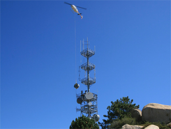
As HPWREN activities grew, the network required increasingly complex equipment installations. "The network has required the installation of numerous large antennae throughout the area," says Jim Hale, an HPWREN technician and installation coordinator. "Coordinating the installation of these antennae, which can be eight to 10 feet in size, and weigh up to 400 pounds, can be a real challenge. We have used hoists, cranes, and in one case even a helicopter, to put radio links in place. This requires a specialized crew of people to climb high towers to secure this equipment, and I make sure it is done safely at all times."
Wildfires, Winds and Floods: HPWREN on the Scene
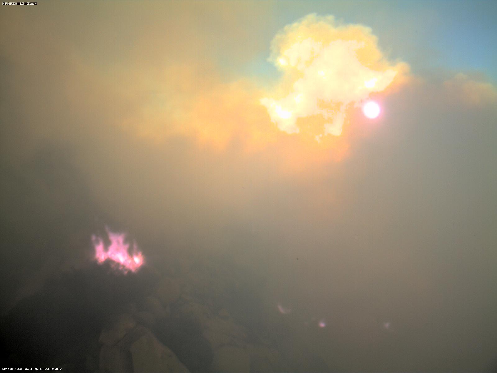
HPWREN gained additional attention for its first responder and public safety activities that were instrumental to firefighter efforts in battling the series of wildfires that burned much of the area in October 2007. For several years already, HPWREN had supported large-scale firefighting operations by connecting several first-responder sites, as well as providing ad-hoc data connectivity and sensor data for six Incident Command Posts in the region. For more information on the 2007 California wildfires, see http://hpwren.ucsd.edu/news/20071030/.
"During the 2007 wildfires, we had literally tens of thousands of different Internet addresses accessing the HPWREN web site," notes Braun. "What's interesting is that our network cameras and sensors, which were themselves threatened by the wildfires, were being widely used not only by first responders, but also by the general public."
Another significant user of HPWREN cameras is the National Oceanographic and Atmospheric Administration's National Weather Service (NOAA/NWS), which typically downloads more than a gigabyte worth of image data each day from the HPWREN server. HPWREN provides automated pager and email alarms to public safety personnel, alerting them in real time of Santa Ana conditions based on continuously processed sensor data.
In January 2010, news media relied on HPWREN cameras for a time-lapse animation of the flash flooding that hit San Diego County. These kinds of animations help illustrate to the public just how quickly flash flooding can approach, where in one minute someone would just get their feet wet crossing the Santa Margarita River, and a few minutes later conditions would probably not be survivable, as a person would likely be swept into rocks by the overpowering current.
"Many of today's science activities require access to real-time and archived sensor data," notes Vernon, a UC San Diego colleague with the university’s Scripps Institution of Oceanography, and HPWREN co-principal investigator from the very beginning 10 years ago. "It is a key enabler to rapid response to interesting events that are observed in data in many scientific disciplines."
Connecting into the Future
Going forward, Braun envisions HPWREN expanding its role of being an enabler for many interdisciplinary and multi-institutional research and education activities, while exploring new models for sustainable cyberinfrastructures for the longer term. Research continues in the area of 'intelligent' network sensors, which would enable data and imagery to be forwarded based on locally determined events rather than continuously. Other projects include continued technology transfers with various partners, including among others the National Park Service, public safety agencies such as CalFire, the U.S. Forest Service, San Diego County’s Sheriff's Department, and several Native American societies.
"HPWREN is a unique national resource, notable for its expertise in tracking wildfires and water resources,” said Larry Smarr, founding director of the California Institute for Telecommunications and Information Technology (Calit2) at UC San Diego, one of HPWREN’s partners. “Their technical know-how and hands-on approach will help us form the wireless backbone of an environmental monitoring program here at Calit2, which will play a vital role not only for public safety, but for public conservation efforts as well.” Like HPWREN, Calit2 will celebrate its 10th anniversary later this year.
About HPWREN
The High Performance Wireless Research and Education Network (HPWREN) is a National Science Foundation-funded network research project, which also functions as a collaborative cyberinfrastructure on research, education, and first responder activities. It includes creating, demonstrating, and evaluating a non-commercial, prototype, high-performance, wide-area, wireless network in the San Diego, Riverside, and Imperial counties. The network includes backbone nodes at the UC San Diego and San Diego State University campuses, and a number of hard-to-reach areas in remote environments. For a brief video overview of HPWREN and its activities, please visit: http://hpwren.ucsd.edu/news/20080316/. For a topological view of the HPWREN program, please visit http://hpwren.ucsd.edu/Topo/.
Related Links
HPWREN
San Diego Supercomputer Center
Scripps Institution of Oceanography
Calit2
National Oceanographic and Atmospheric Administration’s National Weather Service
Media Contacts
Jan Zverina, SDSC Communications, 858 534-5111 or jzverina@sdsc.edu
Warren R. Froelich, SDSC Communications, 858 822-3622 or froelich@sdsc.edu
Comment: Hans-Werner Braun, HPWREN and SDSC, hwb@ucsd.edu
Comment: Frank Vernon, HPWREN and SIO, flvernon@ucsd.edu