

From Jungle Canopy to Sunken World: Digitally Documenting the Wilds of Belize
November 18, 2016 / By Tiffany Fox
San Diego, Calif., Nov. 18, 2016 — Is there anything engineers from the University of California, San Diego Engineers for Exploration (E4E) program won’t do in the name of research?
Sleep in hammocks in a Central American jungle accessible only to those with a permit? Bring it!
Stave off swarms of flying insects while repairing an airplane motor by the light of a headlamp? Meh, it comes with the territory.
Descend more than 260 feet into an untouched sinkhole while carrying heavy equipment? Sure, how much rope have you got?
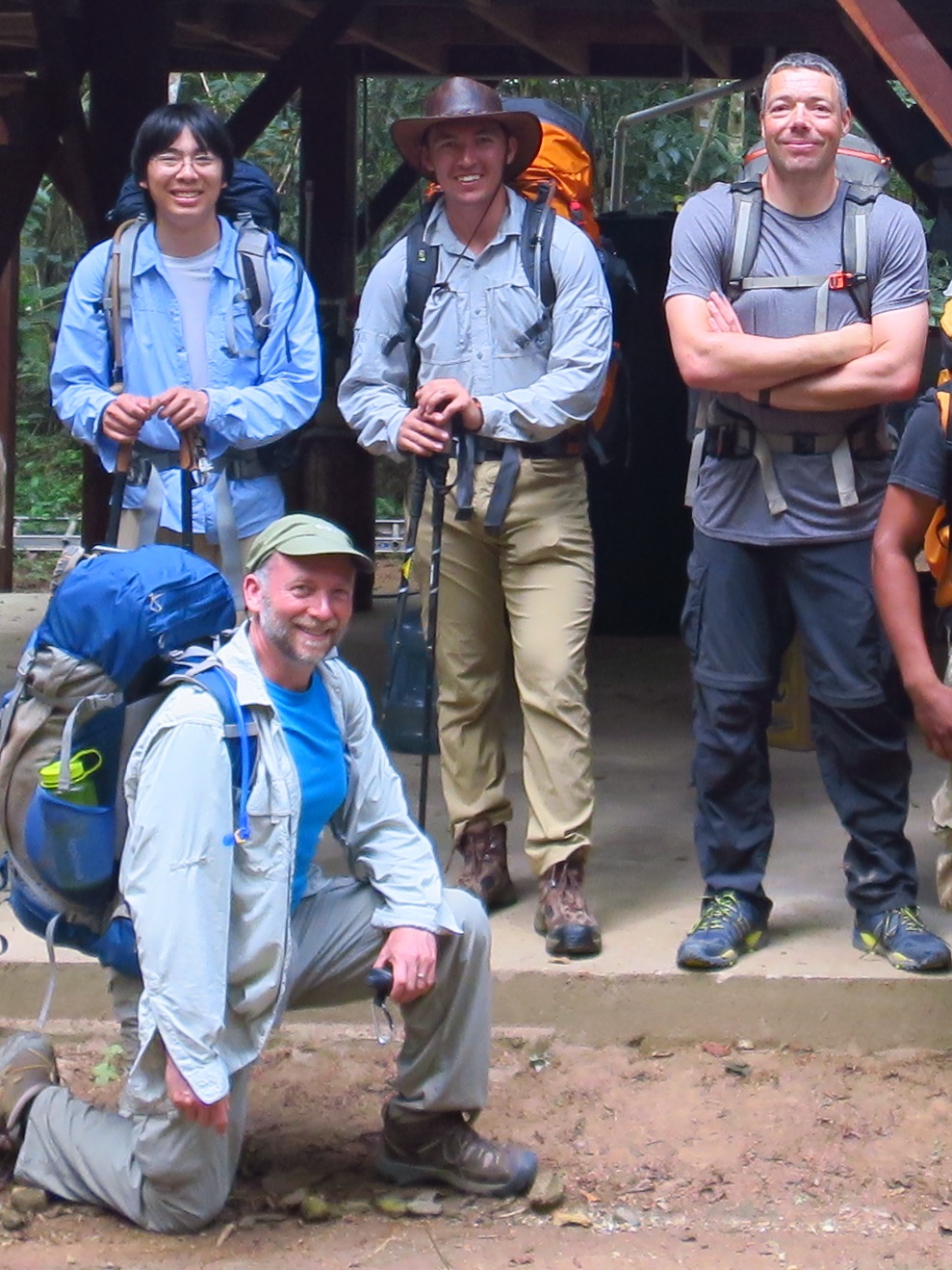
Three E4E researchers braved all this and more as part of a multi-institute collaboration last spring to search for the only known nesting pair of endangered Harpy Eagles in the Central American nation of Belize. The engineers' goal: to find the eagles and document their habitat in the dense Bladen Nature Reserve (BNR) with the help of an off-the-shelf remote-controlled airplane.
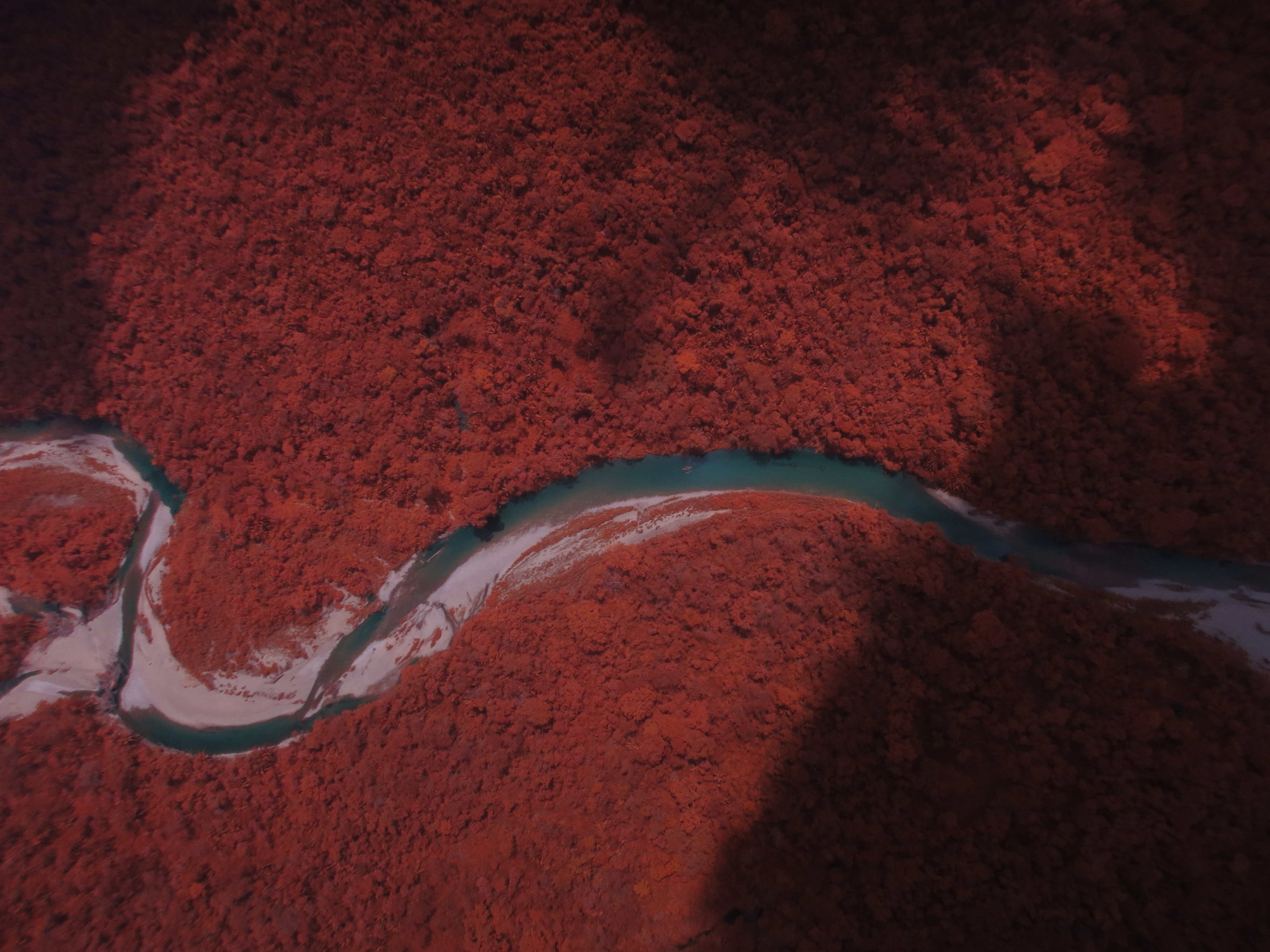
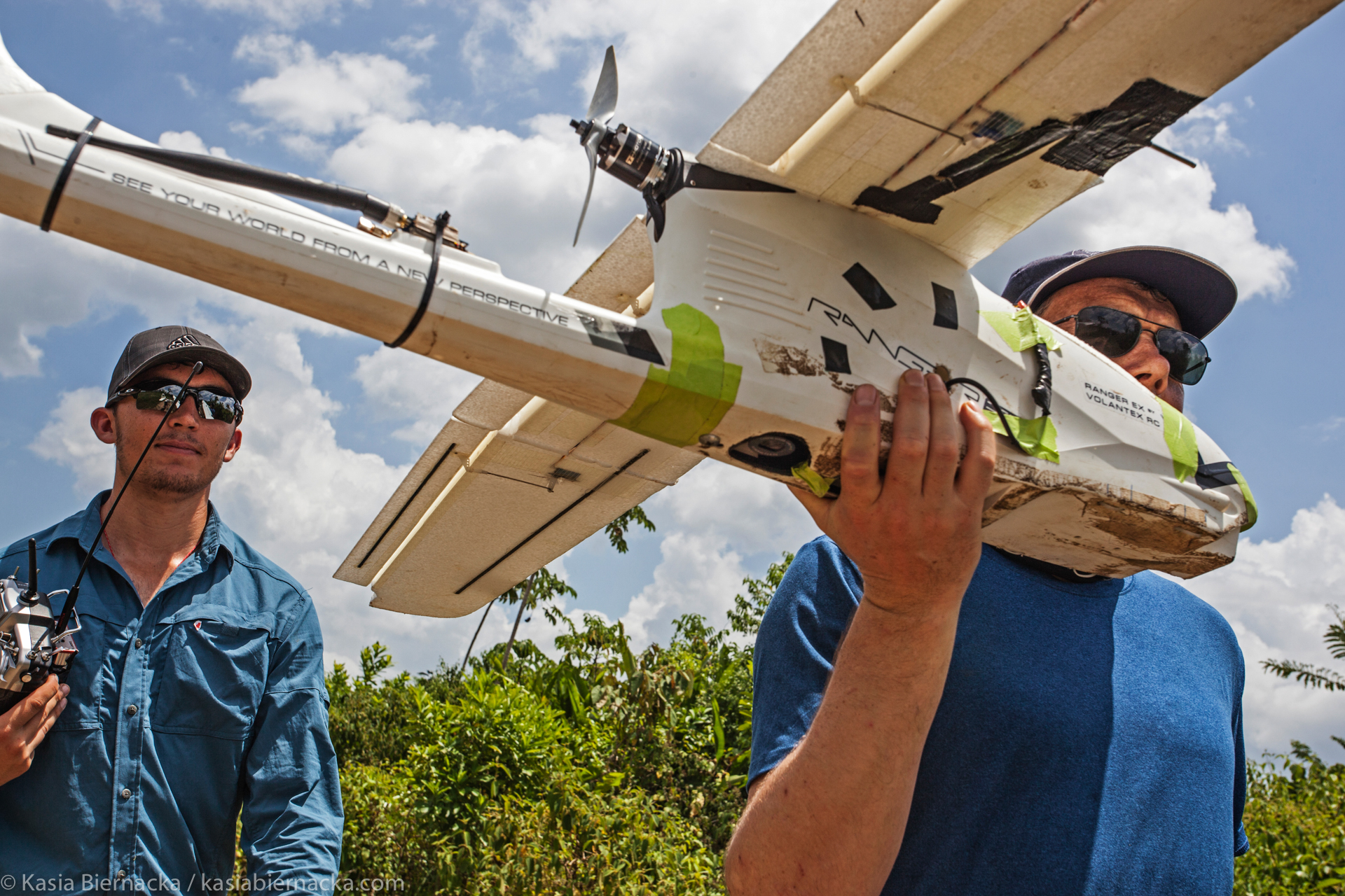
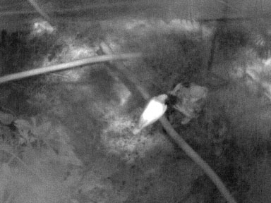
Make that a highly tricked-out remote-control airplane. In the hopes of pinpointing the elusive eagles by the heat they emit, the E4E team outfitted a Volantex Ranger RC plane with autopilot controls, a visible-light camera, a near-infrared camera (which differentiates vegetation in the dense tree canopy) and a thermal camera. The overall goal was to determine what in the BNR’s Oro Valley – be it certain trees or the presence of prey species like spider monkeys – make it an ideal environment for the massive eagles, which are so endangered they were once thought to be extinct in Belize.
An effort is now underway to analyze the data gathered on the mission by Qualcomm Institute researchers Sebastian Afshari (now a senior in the UC San Diego Mechanical and Aerospace department), Principal Development Engineer Curt Schurgers and QI Staff Engineer Eric Lo. With support from the Waitt Foundation, National Geographic, BFREE (the Belize Foundation for Research and Environmental Education), the E4E trio was joined by a research team led by Prof. James Rotenberg of the University of North Carolina, Wilmington Department of Environmental Studies. Engineers for Exploration is a joint partner in Qualcomm Institute’s DroneLab together with the CISA3 center, which provided the CaveCam imaging equipment.
“In the BNR, the Harpy Eagle is an apex predator, which means it has no natural predators,” explains Schurgers, who is an associate director of E4E. “Because of this, the presence of the Harpy Eagle determines a lot of what happens in the ecosystem. It’s a bit like when wolves were reintroduced in Yellowstone (National Park) and everything in the ecosystem changed.”
For the engineers’ purposes, the field expedition was also an opportunity to determine if they could successfully capture thermal imagery and conduct a comprehensive 3D mapping of the BNR using an unmanned aerial vehicle (UAV).
“We didn’t know if it would even be possible to fly there,” says Schurgers. “First of all, it’s a high-humidity environment, which creates a lot of cloud cover. Secondly, we’d have to either send the plane out remotely from afar and fly it really high to account for the hilly topography – which would make for low-resolution image quality – or we’d have to hike into the jungle, where it would be difficult to find a place to launch and land the plane.
“Most historical satellite imagery of this area has cloud cover,” Schurgers continues, “so we knew that being able to deploy an unmanned aerial vehicle on the spot below the clouds or when there weren’t as many clouds would allow us to gather up-to-date data. We also wanted to understand the thermal behavior of the forest. The tree canopy heats up in the middle of the day, so we learned we’d have to fly early in the morning, but we wanted to know if we’d be able to see the Harpy Eagles and other birds then, as well as their chicks and the spider monkeys.”
The UC San Diego team spent their first day at the Belize Zoo and Tropical Education Center, where they tested their ability to capture thermal imagery of a Harpy Eagle pair as well as several spider monkeys kept in captivity. Then came a day spent conducting test flights and long-range mapping missions of the tropical rainforest from BFREE, which provided logistical support for the team.
After that was the six-hour hike deep into the BNR. Lo says he was shocked that “even with all the dense vegetation, the ornithologists (from Rotenberg’s team) would be able to spot birds from so far off.”
It wasn’t just birds the team was looking for, however.
“We were also scouting for places we could launch the plane in the middle of the jungle,” said Schurgers. “In the jungle, if you have a plane, you have to make sure you can actually land it somewhere that is not a tree. There was an area along the river where we set up camp and did a few test flights. We flew the plane manually, always within visible range and low enough to use the thermal camera, and of course, we crashed a few times. But it was robust enough that it could take the hard landings and the takeoffs that weren’t successful.”
Still, it wasn’t easy going. The power system for the plane had died while Afshari and Lo were in transit to Belize, requiring fellow E4E student Antonella Wilby to remove the power system from another plane in their lab back home and send it along with Schurgers two days later. Afshari says the time in between “was the lowest part of the trip” and Wilby’s resourcefulness “saved the expedition.”
“I think our most valuable lesson was that we should bring a spare everything,” Afshari continues, only half-joking. “It was a lot of work on the part of our team to keep all of the systems running in the field. I spent our first night of camping in the jungle removing electronics from the wing of the drone, replacing them with parts that didn’t quite fit, and the whole time I had every single bug in Belize flying straight at my headlamp. I’m pretty sure some of them are glued to the plane still.”
In the end, says Afshari, even though the plane was “held together with duct tape and zip ties and was flying with missing parts through a rain cloud, we got all the data we needed.
“We were able to capture the highest resolution aerial imagery of the Bladen Nature Reserve (BNR) that I know of,” he adds. “Every year, BFREE tries to use a small airplane to image their boundaries, but they have never been able to put together a comprehensive map of the whole area, let alone much of the Reserve. Our data will allow scientists to assess the health and diversity of the BNR, as well as analyze the habitats of the various animals living there. It will provide access to the beautiful landscape, and records of its state and how it changes over time, in an accessible format.”
Adds Schurgers: “If we spent a month there, we’d be able to get crystal clear imagery of the area, so really we showed this is a pretty powerful use of technology. Although, admittedly we did fly through a cloud; there’s a gap in our imagery where it’s just white.”
But it wasn’t only aerial imagery the team was able to capture. “Along with our collaborators, we also wanted to get a look at the biodiversity of the ecosystem from the bottom up,” says Schurgers.
And when he says bottom, he means bottom. As in, descending by rope 260 feet into a sinkhole to access an ecosystem so isolated that a previously unknown species of snail lives there and nowhere else on earth. Schurgers, Lo and Afshari were three of 10 known people to have accessed the sinkhole – ever.
“None of us are cavers, so we practiced using the gear while at home and we got some training from cavers in Belize. But going down into that sinkhole was really far,” says Lo, who, while descending, carried on his back a camera-equipped quadcopter that the team later used to capture a fully immersive 360-degree 3D view of the sinkhole. “Descending is the fun part because you can control how fast you are going. It’s almost like dropping into 'Jurassic World' with all the green ferns and trees everywhere and water dripping down. It’s beautiful.”
And then came the hard work of the ascent, which Schurgers likens to climbing a rope in gym class – only a rope that’s about 3⁄4 the length of a soccer field. Schurgers recalls that “Sebastian volunteered to go up twice in order to charge the batteries for the quadcopter, and when he came back down the first time he said, ‘I don’t want to do that again.’ It’s definitely hard work, and we were also carrying the drone, the CAVECam gear for taking 3D imagery and other equipment.”
In the end, the ornithologists never did find the nesting pair of Harpy Eagles during the expedition – which means the E4E team couldn’t determine if the UAV was an effective means for capturing thermal imagery of the birds. Nevertheless, the team presented their methods and data in Washington D.C. this past August at the North American Ornithological Conference, the largest ornithology conference in North America.
“(Our study was) inconclusive,” says Schurgers. “If there were eagles the birders would have found them, but since there were no eagles we couldn’t test our sensors. But this was an exploratory mission. If we’re able to get the data we need at some point, the next step would be to classify (possibly through crowd sourcing) interesting pieces of data, whatever those are – maybe it’s finding nests, maybe it’s finding densities of monkeys. From the data, we would see if we could infer something useful.”
The team did, however, successfully acquire high-resolution imagery of unexplored areas of the Bladen Nature Reserve, and also brought home some great memories.
“Meeting all of the incredible passionate scientists and explorers was absolutely incredible,” says Afshari. “I have never met anyone with so much character and personality as that crew, and I hope to see them all again. (Another highlight was) seeing the beauty of the Bladen, and experiencing the food and the kindness of Belize. And showering when we got home.”
Related Links
University of North Carolina, Wilmington Department of Environmental Studies
Media Contacts
Tiffany Fox
(858) 246-0353
tfox@ucsd.edu